Orbiting Carbon Observatory-2OCO-2
OCO-2 data began coming in about 45 days after launch. Why this time delay? It took some time and maneuvering to get the satellite positioned exactly where we wanted it to be, in the right position in the A-train Constellation. After that, the mission operations team carefully turned on all the components and performed checks to make sure everything was working correctly. Only after that, will the instrument go into work mode and start collecting data. On OCO-2, the data are stored on board and the information is sent down in bundles during orbit. Data and information (telemetry) are sent back to Earth and "collected" by the ground stations. Once the data are collected, they still need to be processed. OCO-2 data will be processed at the Jet Propulsion Laboratory and ultimately distributed and stored at the Goddard Earth Science Data & Information Services Center (GES DISC).
NASA Earth Satellite data products, including OCO-2, are processed at various levels ranging from Level 0 to Level 4. Unless a satellite is flying an actual camera, the data that comes back does not look like a picture or image. It must be created by the science team! Level 0 products are raw data at full instrument resolution. With each progressive level (1-4), the data are converted into more useful formats, such as a map and with more specific variables such as location and time.
The OCO-2 Science Data Operations System (SDOS) converts automated readings downloaded from the Observatory into data products that provide comprehensive mission results as well as material for further research and investigation. The SDOS provides the environment to generate two data products (i.e., L1 and L2) that will be available for distribution to both the scientific community and the general public. Both products appear in the Hierarchical Data Format (HDF) v 5. The products conform to the standards of the Earth Observing System Data and Information System (EOSDIS) Core System (ECS).
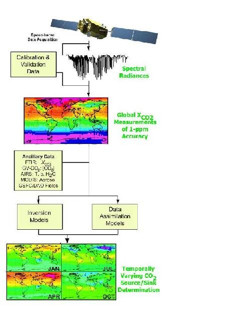
The OCO-2 Level 1B product list calibrated and geo-located spectral radiances. Each Level 1B product will contain a unique record for every sounding that the OCO-2 instrument acquires while viewing the Earth during a single spacecraft orbit. Each sounding will consist of the three collocated spectra. Each of these spectra will correspond with one of the three spectrometer channels. If the instrument acquires data continuously over the entire daylight side of the Earth, the Level 1B Product will contain approximately 72,000 soundings per orbit. The Level 1B product also includes error measures and indicators that assess the quality of each acquired spectrum. These indicators denote which spectra are suitable for subsequent processing.
The OCO-2 Level 2 product will provide several retrieved atmospheric and geophysical measures. The retrieved data in each product will be based on the spectra that were acquired during the same OCO-2 spacecraft orbit. The presence of clouds, thick aerosols and topographic inhomogeneities inhibits the retrieval process. A typical Level 2 Product will likely list the output from about 9,400 retrievals. The retrieved data will include vertical atmospheric profiles of temperature, CO2 and water vapor as well as aerosol content. Each vertical profile will appear as an array in the Level 2 Product. Each element in these arrays will represent a location in the vertical profile. Retrieved data will also include scalar measures of albedo, surface pressure and the column averaged dry air CO2 mole fraction (Xco2). The Level 2 product will contain error measures and indicators that assess the quality of the data output. These indicators will specify whether the retrieved data sets are suitable for subsequent processing.
OCO-2 will be providing a variety of data products to the public. The calibrated spectral radiance (L1B) products are discussed on the calibration page. The OCO-2 Level 2 product is the key data product for the CO2 data. There will be a standard L2 product, and then a diagnostic product that has a larger volume, because it contains additional information. The retrieved data in each product will be based on the spectra that were acquired during the same OCO-2 spacecraft orbit. The presence of clouds, thick aerosols and topographic inhomogeneities inhibits the retrieval process. A typical daily Level 2 Product will likely list the output from about 10,000 retrievals. Both L2 products include the column averaged dry-air CO2 mole fraction, referred to as XCO2, as well as other parameters that we co-retrieved, such as water vapor profile, temperature profile offset, surface albedo, and aerosol and cloud profiles. Both L2 products will contain error measures and indicators that assess the quality of the data output. These indicators will specify whether the retrieved data sets are suitable for subsequent processing. The diagnostic L2 product also contains the averaging kernels, covariance matrices, and radiance spectra, and are useful for scientists who will assimilate these data into their global models.
For most users' convenience, the team also produces "lite" files for the Xco2 and Solar Induced Fluorescence (SIF) products. The Xco2 lite file contains quality screen data extracted from the L2 Standard files. Critical fields are included and a bias correction is applied. The condensed files are aimed at scientists seeking to do data assimilation. Similarly, a lite file will be produced for the SIF information from L2IDP. Again, one day is packaged in one file, simplifying time series analysis.
The OCO-2 team will also be releasing the data from the IMAP-DOAS (Iterative Maximum a Posteriori Differential Optical Absorption Spectroscopy) preprocessor (L2IDP). This is a fast algorithm that is used to assist in identifying the cloudy scenes. It is also the key algorithm for the retrieval of solar-induced fluorescence (SIF), and provides a larger set of SIF retrievals than are contained in the L2 product.
Members of the OCO-2 science team will generate Level 3 and Level 4 products at their home institutions. The Level 3 product will map Xco2 to one part per million (ppm) accuracy over the Earth's surface in bins with dimensions of 1° in latitude and 1° in longitude. Each granule of the OCO-2 Level 3 product will represent data from one 16 day orbit repeat cycle. The Level 4 product will map the distribution of CO2 sources and sinks over the Earth's surface. Plots of the Level 4 product will display fluxes in CO2 abundance over the Earth's surface in regions with dimensions of 4° in latitude and 5° in longitude.
| OCO-2 Data Products | |||
| Level | Data Product | Data Rate | Frequency |
| 1B | Orbit granules of calibrated radiances | 19.95 Gbytes/day | 30 days |
| L2|DP | Orbit granules of solar induced fluorescence | 1.70 Gbytes/day | 18-19 days |
| L2Std | Orbit granules of geolocated Xco2 | 0.54 Gbytes/day | 18-19 days |
| L2Dia | Orbit granules of geolocated Xco2, screened for quality | 11.95 Gbytes/day | 18-19 days |
| Lite | Daily files of geolocated Xco2, screened for quality | N/A | N/A |
| 3 | Global Xco2 | N/A | N/A |
| 4 | Global CO2 sources and sinks | N/A | N/A |
Science Data Products